- Dialing code: +599
- Area: 113.5 mi² (294 km²)
- Currency: United States Dollar
- Official language: Dutch

And while English is widely spoken, nothing will get you further than a few choice phrases in Papiamentu, the language of the Dutch Caribbean. Meet some remarkable people on the culture page and explore some of the many historical milestones of Bonaire.
Welcome to Bonaire, or, as we say in Papiamentu , Bon Bini!
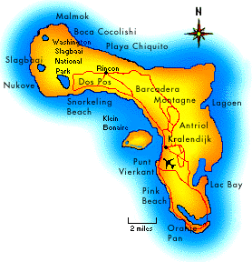
Location: 30 miles (48 km) from Curacao; 50 miles (80 km) north of Venezuela and 86 miles (129 km) east of Aruba, outside of the Caribbean hurricane belt.
Size: 24 miles (39 km) long by 3-7 miles wide, 112 square miles (290 km2). Highest elevation is Brandaris Hill, 784 feet (240 meters).
Climate: Yearly average temperature is 82°F (27.8°C); water temperature of 80°F (26.7°C); rainfall of 22 inches (56 cm); humidity of 76%. Sunny, all year round.
Information Provided by:
http://www.geographia.com/bonaire
We will be living here for our duration:
http://www.sunrentalsbonaire.com/vacations/kaya-venus-17.html

No comments:
Post a Comment